Tuesday, May 14, 2024
Citizens of Coryell County can now find out whether their home is in an area that is at risk for wildfires through an online, interactive map.
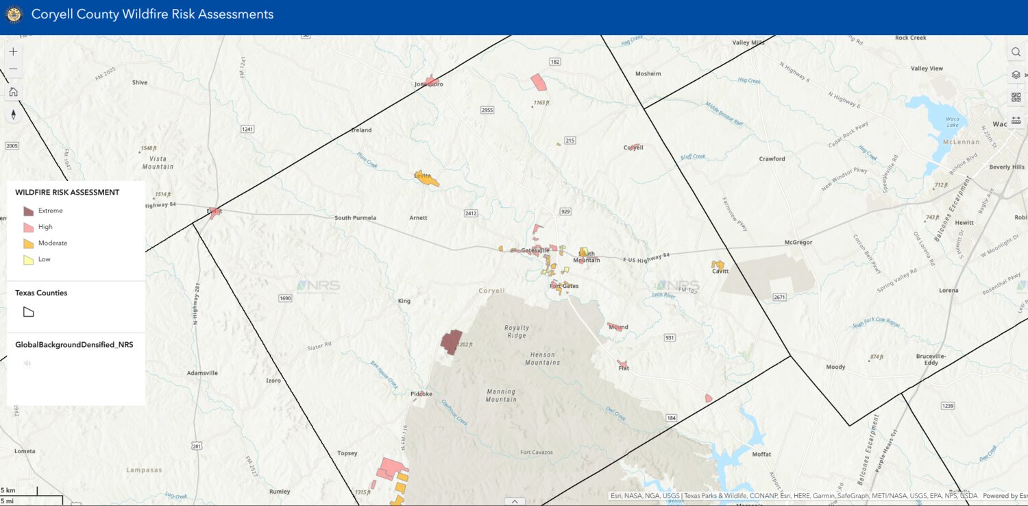
The wildfire risk assessment map is part of the development of the Coryell County Community Wildfire Protection Plan (CWPP), which aims to help reduce the risk of wildfires and ensure the safety of properties and homes. The risk assessments for the maps were conducted by Natural Resources Solutions, L.C. with assistance from the Texas A&M Forest Service, two of the groups helping Coryell County create the CWPP.
“After we find these risk assessments and how their neighborhoods are rated, we’ll be tailoring specific mitigation projects for all of the county and things of that nature to be included into the CWPP,” said Lillian Reed with Natural Resource Solutions.
To create the map, Casey Childers, a land management specialist with Natural Resource Solutions, said they had a training with the Texas A&M forest Service on how to use a community assessment tool to determine which communities are at highest risk of wildfires. After the training, Childers visited neighborhoods throughout the county to determine the ratings of wildfire risks for certain properties.
“I drove around and looked at things like how thick the trees in yard are, how tall they are, was there debris on the roof, was there debris in the storm gutters or the rain gutters, what was the composition of the house,” Childers said. “If (the house) was made of brick or combustible material such as wooden windows, or whether they were double paned or single paned.”
Childers said after he answered the assessment’s questions about the environment of various properties, it would calculate a wildfire risk rating for the community.
Citizens can access the Coryell County Wildfire Risk Assessments on the CWPP website under the resources tab. The map allows users to zoom in on their property and see if it’s considered high or low risk for wildfires. The wildfire risk ratings are labeled as low, moderate, high, and extreme.
“The number one cause of structure ignitions during a wildfire is from embers ahead of the fire,” said Kiley Moran, the Texas A&M Forest Service Wildland Urban Interface (WUI) Coordinator for McGregor. “When an ember lands on the dry leaves that are under your deck or front porch with leaves piled up or your roof that’s in poor shape, those embers can ignite, and those things very quickly can cause the fire to spread to other parts of your home.”
If a property is a high-risk area, Moran said one of the first steps to make a home more fire resistant is to provide basic maintenance around the property, such as clearing away brush and dead leaves in the gutters and sealing up any holes in the house or vents.
Once the CWPP is complete, the county can apply for the Community Wildfire Defense Grant, which will help provide funding for additional wildfire mitigation strategies.
“This piece of the CWPP is what citizens can do on an individual level to reduce the threat of fires and wildfires,” said Coryell County Judge Roger Miller.
The final public meeting for the CWPP will be held on Oct. 11 at 6 pm and will discuss the findings from the risk assessments as well as answer questions from the public.
Learn more about Coryell County’s Community Wildfire Protection Plan on www.coryellcountycwpp.com.